Eddie Garcia: ‘Explosive’ fire threat expected Friday, cooler conditions to follow
[anvplayer video=”5103965″ station=”998127″]
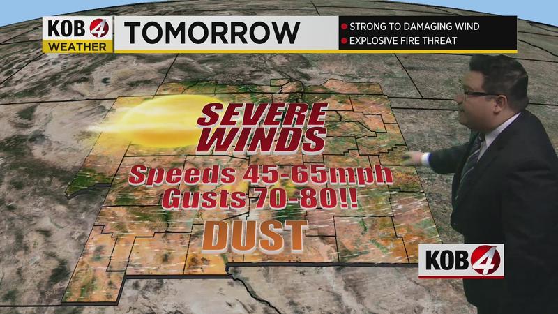
ALBUQUERQUE, N.M. — While Thursday will be a calmer day for New Mexico, Friday is expected to bring high fire danger to the state before conditions cool down this weekend.
For Thursday, it will be breezy in the southern and lower-elevation areas of the state, where temperatures will be in the 90s. Some winds are expected in northern and central New Mexico, with temperatures in the upper-70s and lower-80s – and smoke rolling into the Four Corners region from the fire near Flagstaff.
All of this is before severe winds roll in for Friday as gusts as high as 80 MPH will ignite the fire danger.
Eddie Garcia has a mid-Thursday weather update. Click the video above to see what the weather will be like for your town.
The National Weather Service Albuquerque issued a Red Flag Warning at 3:07 a.m. Thursday. This warning is in effect through 9 p.m. Friday:
- AREA AND TIMING…Northwest Plateau, North Central Mountains, Northwest Highlands, Middle Rio Grande Valley, Sandia, Manzano and Gallinas Mountains and the West Central Highlands Friday morning through Friday evening.
- 20-FOOT WINDS…South to southwest 35 to 45 mph with occasional gusts to 60 mph on Friday.
- RELATIVE HUMIDITY…Ranging from 5 to 10 percent Friday afternoon.
- IMPACTS…Any fires that develop will likely spread rapidly and will be hard to control. Long-range spotting and extreme fire behavior will be possible. Outdoor burning should not be done.